
Swallowtree Bay anticline-syncline couplet: detail…
Swallowtree Bay anticline-syncline couplet: detail…
Swallowtree Bay anticline-syncline couplet: detail…
River Porter waterfall (5)
River Porter waterfall (1)
River Porter waterfall (2)
River Porter waterfall (3)
River Porter waterfall (4)
River Porter waterfall in spate: video clip
Houndkirk Hill north-west escarpment
Path to Houndkirk Hill
Scarp edge of Houndkirk Hill
Summit rocks of Houndkirk Hill 1
Summit rocks of Houndkirk Hill 2
View north-east from Houndkirk Hill escarpment
Summit of Houndkirk Hill looking NE
Summit of Houndkirk Hill looking NNE
Summit rocks of Houndkirk Edge looking NE to Hound…
View north-east over Houndkirk Moor from the shelt…
View west to Over Owler Tor from Houndkirk Road
View WNW to Higger Tor from Houndkirk Road
View north to Houndkirk Hill from Houndkirk Road
Swallowtree Bay anticline-syncline couplet: detail…
Swallowtree Bay anticline-syncline couplet: detail…
Swallowtree Bay anticline-syncline couplet: detail…
Swallowtree Bay anticline-syncline couplet: detail…
Swallowtree Bay anticline-syncline couplet: detail…
Swallowtree Bay anticline-syncline couplet
Syncline in Lower Coal Measures sandstones: Swallo…
Asymmetric anticline, Swallowtree Bay north
Ladies Cave Anticline: interior hinge zone
Ladies Cave Anticline
Small thrust and footwall syncline
Extentional faults detail: Saundersfoot south
Extentional faults: Saundersfoot south
Stackpole Head from Mowingword Point
Lattice Windows sea arches and Barafundle Bay
Barafundle Bay cloudscape from Stackpole Head
Mowingword Bay, Pinnacle Stack and Gun Cliff
Lichens and Viper's Bugloss on Mowingword Point
Sandy Pit doline panorama
Sandy Pit doline
Box Bay with caves
Box Bay panorama
Church Rock from Saddle Point
Broad Haven (S) view east to Stackpole Head and Ca…
Gateholm and Skokholm Islands
Victoria Bay and Skokholm Island
Victoria Bay bedding planes in Silurian sandstones
St Brides Haven: colourful rocks, colourful sea
St Brides Haven - view east
St Brides Haven solifluction deposit
Druidston Haven: Cliff Section 5
Druidston Haven: Cliff Section 3
Druidston Haven: Cliff Section 2
Druidston Haven: Cliff Section 2 interpretation
Druidston Haven: Cliff Section 1 panorama
Druidston Haven: Cliff Section 1 interpretation
Druidston Haven: Cliff Section 3 interpretation
Druidston Haven: Cliff Section 4 interpretation
Druidston Haven: Cliff Section 4
Druidston Haven: Cliff Section 5 interpretation
Druidston Haven: Cliff Section 6 interpretation
Druidston Haven: Cliff Section 6
Gravel Bay - Moor Cliffs Formation with calcretes…
East Pickard Bay - English stonecrop
Waves in Freshwater West
Gravel Bay - Moor Cliffs Formation
East Pickard Bay panorama
Freshwater West walkies
Spray haze over Freshwater West
Gravel Bay - calcrete horizon in Moor Cliffs Forma…
Gravel Bay - Moor Cliffs Formation with calcretes…
Gravel Bay - Moor Cliffs Formation 2
Gravel Bay - millipede-like burrows in Moor Cliffs…
Gravel Bay - Moor Cliffs Formation 1
Conglomerate at Gravel Bay: close-up view 2
Conglomerates at Gravel Bay
Conglomerate at Gravel Bay: close-up view 1
View to North Screapadal
View west up Screapadal
South Screapadal houses
Creag na Bruaich 2
Creag na Bruaich 1
1/60 • f/6.3 • 15.0 mm • ISO 400 •
Canon EOS 600D
EF-S15-85mm f/3.5-5.6 IS USM
Location
See also...
See more...Keywords
Authorizations, license
-
Visible by: Everyone -
All rights reserved
-
137 visits
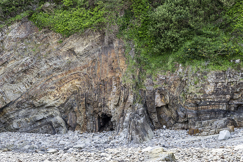
Swallowtree Bay anticline-syncline couplet: detail 6


Saundersfoot to Swallowtree Bay geological structures
Detail view no.6 of the asymmetric anticline-syncline couplet in Lower Coal Measures sandstones and siltstones, just south of Swallowtree Bay.
This photo mainly shows the vertical limb of the fold couplet pair. The axis of the anticline is on the left. In the centre, the vertical limb is composed mainly of sandstones with thin darker silty laminae. The sandstone beds show a strong fracture fan cleavage perpendicular to the bedding, especially marked on this vertical limb of the fold.
I took this photo for the shapes, textures and colours as well as the geological interest, hence I omitted a scale object. The section shown is about 2 metres in height.
The photo of the entire structure is here:
- Keyboard shortcuts:
Jump to top
RSS feed- Latest comments - Subscribe to the comment feeds of this photo
- ipernity © 2007-2024
- Help & Contact
|
Club news
|
About ipernity
|
History |
ipernity Club & Prices |
Guide of good conduct
Donate | Group guidelines | Privacy policy | Terms of use | Statutes | In memoria -
Facebook
Twitter
Sign-in to write a comment.