Mowingword Bay, Pinnacle Stack and Gun Cliff
Lichens and Viper's Bugloss on Mowingword Point
Stackpole Head from Mowingword Point
Barafundle Bay cloudscape from Stackpole Head
Lattice Windows sea arches and Barafundle Bay
Small thrust and footwall syncline
Extentional faults: Saundersfoot south
Extentional faults detail: Saundersfoot south
Ladies Cave Anticline
Ladies Cave Anticline: interior hinge zone
Asymmetric anticline, Swallowtree Bay north
Syncline in Lower Coal Measures sandstones: Swallo…
Swallowtree Bay anticline-syncline couplet
Swallowtree Bay anticline-syncline couplet: detail…
Swallowtree Bay anticline-syncline couplet: detail…
Swallowtree Bay anticline-syncline couplet: detail…
Swallowtree Bay anticline-syncline couplet: detail…
Swallowtree Bay anticline-syncline couplet: detail…
Swallowtree Bay anticline-syncline couplet: detail…
Swallowtree Bay anticline-syncline couplet: detail…
Swallowtree Bay anticline-syncline couplet: detail…
Swallowtree Bay anticline-syncline couplet: detail…
Hornet hoverfly - Volucella zonaria
Sandy Pit doline
Box Bay panorama
Box Bay with caves
Church Rock from Saddle Point
Broad Haven (S) view west
Broad Haven (S) view east to Stackpole Head and Ca…
Gateholm and Skokholm Islands
Victoria Bay bedding planes in Silurian sandstones
Victoria Bay and Skokholm Island
St Brides Haven - view east
St Brides Haven: colourful rocks, colourful sea
St Brides Haven solifluction deposit
Druidston Haven: Cliff Section 1 interpretation
Druidston Haven: Cliff Section 1 panorama
Druidston Haven: Cliff Section 2 interpretation
Druidston Haven: Cliff Section 2
Druidston Haven: Cliff Section 3 interpretation
Druidston Haven: Cliff Section 3
Druidston Haven: Cliff Section 4 interpretation
Druidston Haven: Cliff Section 4
Druidston Haven: Cliff Section 5 interpretation
Druidston Haven: Cliff Section 5
1/500 • f/6.3 • 15.0 mm • ISO 400 •
Canon EOS 600D
EF-S15-85mm f/3.5-5.6 IS USM
Location
Lat, Lng:
You can copy the above to your favourite mapping app.
Address: unknown
You can copy the above to your favourite mapping app.
Address: unknown
See also...
Keywords
Authorizations, license
-
Visible by: Everyone -
All rights reserved
-
220 visits
Sandy Pit doline panorama


Broad Haven (south) to Stackpole Head
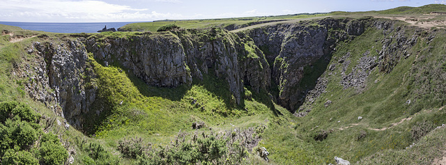
Immediately inland from Box Bay in the previous photo is the 'Sandy Pit' doline; a large karst solution hollow. There is a connection with the sea at the base, so marine erosion has probably contributed to the enlargement of the hollow.
The name 'Sandy Pit' possibly refers to a partial filling with post-glacial blown sand (subsequently largely exploited and excavated?)
This panoramic view shows the large size of the doline and consists of three landscape photos stitched together with Photoshop software.
- Keyboard shortcuts:
Jump to top
RSS feed- Latest comments - Subscribe to the comment feeds of this photo
- ipernity © 2007-2025
- Help & Contact
|
Club news
|
About ipernity
|
History |
ipernity Club & Prices |
Guide of good conduct
Donate | Group guidelines | Privacy policy | Terms of use | Statutes | In memoria -
Facebook
Twitter

Earthwatcher club has replied to neira-Dan clubIl y a beaucoup de calcaire sur cette côte. Les processus karstiques sont importants pour créer le paysage.
Sign-in to write a comment.