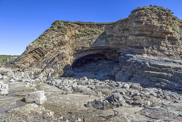
Fox Hole Anticline - northern limb
Fox Hole Anticline - northern limb 2
Fox Hole Anticline - northern limb 3
Fox Hole Anticline - northern limb jointing with c…
Fox Hole Anticline - northern limb with mine adit
Little Haven - The Settlands panorama
Little Haven - The Settlands panorama - geological…
Little Haven - The Settlands; recumbent fold, thru…
Little Haven - The Settlands; recumbent fold, thru…
Little Haven - The Settlands; detail of southern a…
Little Haven - The Settlands; detail of incompeten…
Little Haven - The Settlands; detail of incompeten…
Little Haven - The Settlands; detail of overturned…
Little Settlands - incompetent deformation 1
Little Settlands - incompetent deformation 2
Little Settlands - inverted thin coals and disturb…
The Settlands sand trees 1
The Settlands sand trees 2
The Settlands sand trees 3
Marros Sands
Marros Sands panorama
Marros Sands and Top Castle hill fort panorama
Marros west cliffs
Little Haven north side geological interpretation
Little Haven north side panorama
Little Haven view north over Rooks Bay and The Set…
The Settlands at Little Haven from coastal path
Newgale Sands 3
Small Copper at Trefrane Cliff Colliery
Trefrane Cliff Colliery chimney 4
Trefrane Cliff Colliery chimney 3
Trefrane Cliff Colliery chimney 2
Trefrane Cliff Colliery chimney 1
Newgale Sands 2
Newgale Sands 1
Rickets Head Black Cliff Colliery tip and Newgale
Rickets Head south mining activity panorama
Rickets Head end-on view
Rickets Head north mining activity panorama
Nolton Haven seaward view
Nolton Haven channel lag deposit in beach boulder…
Nolton Haven channel lag deposit in beach boulder…
Nolton Haven channel sandstones 3
Nolton Haven channel sandstones 2
Nolton Haven channel sandstones
1/60 • f/8.0 • 15.0 mm • ISO 100 •
Canon EOS 600D
EF-S15-85mm f/3.5-5.6 IS USM
Location
Lat, Lng:
You can copy the above to your favourite mapping app.
Address: unknown
You can copy the above to your favourite mapping app.
Address: unknown
See also...
Keywords
Authorizations, license
-
Visible by: Everyone -
All rights reserved
- Photo replaced on 06 Jun 2020
-
172 visits
Little Haven - Fox Hole Anticline


Structural geology of Little Haven and The Settlands
The cliffs from Little Haven to Broad Haven (and northward) display a spectacular range of geological structures, folding, faulting and thrusting, mainly in the Lower Coal Measures. The relatively weak mudstone and shale-dominated sequences show much incompetent deformation: tight, thrusted and overturned folds, in contrast to the thicker, stronger, sandstones which have formed relatively open and concentric folds.
This is a view of the Fox Hole anticline taken from beach level. The style of folding is open and concentric, largely due to the competent (strong) nature of the sandstone of which it is comprised. A thin coal in the core of the anticline has largely been extracted by mining.
The sandstone displays a number of sedimentary features, including cross-bedding and channel erosion, formed by deposition in a high-energy delta distributary channel setting. Restoring the anticline to its 'unfolded' condition, these sedimentary structures then indicate a general current flow direction from south-west to north-east.
Folding, faulting and thrusting make determination of the exact stratigraphic correlation of the Fox Hole sandstone difficult, but it is reasonably clear that this is the lowest stratigraphic unit in the Little Haven area and is well down in the Lower Coal Measures sequence.
- Keyboard shortcuts:
Jump to top
RSS feed- Latest comments - Subscribe to the comment feeds of this photo
- ipernity © 2007-2025
- Help & Contact
|
Club news
|
About ipernity
|
History |
ipernity Club & Prices |
Guide of good conduct
Donate | Group guidelines | Privacy policy | Terms of use | Statutes | In memoria -
Facebook
Twitter

Bienvenue dans le groupe , que de belles contributions
Earthwatcher club has replied to neira-Dan clubSign-in to write a comment.