Nolton Haven seaward view
Rickets Head north mining activity panorama
Rickets Head end-on view
Rickets Head south mining activity panorama
Rickets Head Black Cliff Colliery tip and Newgale
Newgale Sands 1
Newgale Sands 2
Trefrane Cliff Colliery chimney 1
Trefrane Cliff Colliery chimney 2
Trefrane Cliff Colliery chimney 3
Trefrane Cliff Colliery chimney 4
Small Copper at Trefrane Cliff Colliery
Newgale Sands 3
The Settlands at Little Haven from coastal path
Little Haven view north over Rooks Bay and The Set…
Little Haven north side panorama
Little Haven north side geological interpretation
Little Haven - Fox Hole Anticline
Fox Hole Anticline - northern limb
Fox Hole Anticline - northern limb 2
Fox Hole Anticline - northern limb 3
Fox Hole Anticline - northern limb jointing with c…
Fox Hole Anticline - northern limb with mine adit
Nolton Haven channel lag deposit in beach boulder…
Nolton Haven channel sandstones 3
Nolton Haven channel sandstones 2
Nolton Haven channel sandstones
Nolton Haven sandstone channel scours
Nolton Haven ironstone pebbles in channel lag depo…
Nolton Haven ironstone pebbles in channel lag depo…
Nolton Haven sandstone channel edge lag deposits 2
Nolton Haven sandstone channel edge lag deposits 1
Nolton Haven sandstone channel edge 2
Nolton Haven sandstone channel edge 1
Nolton Haven north west cliffs of Pennant Sandston…
Tenby Church and seafront buildings from Castle Hi…
Tenby North Sands skyscape from Castle Hill 2
Tenby North Sands skyscape from Castle Hill 1
Tenby North Sands with Inshore Rescue Boat station
Tenby from North Sands
Tenby skyscape
Tenby North Sands chevron fold couplet structural…
Tenby North Sands chevron fold couplet panorama
Tenby North Sands chevron fold couplet
Green Bridge of Wales
1/200 • f/6.3 • 85.0 mm • ISO 200 •
Canon EOS 600D
EF-S15-85mm f/3.5-5.6 IS USM
Location
Lat, Lng:
You can copy the above to your favourite mapping app.
Address: unknown
You can copy the above to your favourite mapping app.
Address: unknown
See also...
See more...Keywords
Authorizations, license
-
Visible by: Everyone -
All rights reserved
-
189 visits
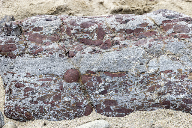
Nolton Haven channel lag deposit in beach boulder 2


Nolton Haven to Newgale
The small Nolton-Newgale coalfield is separated by faulting from the main Pembrokeshire coalfield. It lies mostly within Pennant Sandstone Formation of the Upper Coal Measures rocks.
The cliffs of Nolton Haven expose predominantly deltaic channel sandstones, often with highly erosive bases with coarse, rip-up, channel-lag deposits. The general dip is around 20° to the south-west.
This photo shows a cross-section view of a locally derived beach boulder consisting of a channel lag deposit with ironstone pebbles and fragments set in a pale grey coarse sandstone matrix. The boulder is approx. 50 cm thick.
- Keyboard shortcuts:
Jump to top
RSS feed- Latest comments - Subscribe to the comment feeds of this photo
- ipernity © 2007-2025
- Help & Contact
|
Club news
|
About ipernity
|
History |
ipernity Club & Prices |
Guide of good conduct
Donate | Group guidelines | Privacy policy | Terms of use | Statutes | In memoria -
Facebook
Twitter

Sign-in to write a comment.