
H.F.F with Che Guevara
The WALL
Via FERRATA
Lago di Toblino
Monte Casale
Solitude ?
Solitude !
Rondane mountains.
Døråldalen valley in the Rondane mountains.
Dørålen, Rondane mountains.
Camping in Dørålen, Rondane mountains.
Clouse up of the Rondane mountains.
Fossil deltas from the end of the last ice age, Dø…
The icy lake in Dørålen, Rondane mountains.
Dørålen / Døråldalen, Rondane mountains.
Lofer Mountains
Chapel St. Antonius
Mi roque.
climber
Hochsitz (2) für bk*
Mountaineers Dreams
sonnig
Lofer Mountains from the West
Mitterhorn, 2.506m
To the Mitterhorn via "Naked Dog"
My Dream
Τ = Toleranz
Kiss of the Morning Sun
It's Your Own Risk
Looking Back
Mountaineers Rule #14
Tre Cime
Distant mountains
Herbst
Altenahr - Weinberge DSC00866
Altenahr - Weinberge DSC00869
Altenahr - Weinberge DSC00871
Altenahr - Weinberge DSC00872
Altenahr - Weinberge DSC00875
Altenahr - Rotweinwanderweg
Arbustos decolorados.
Quabbin Reservoir in the Snow
A house in the mountain
Blankenheim Ahrdorf 20160619_213158
Altenahr - Burg Are und Eisenbahntunnel 20161030_1…
Altenahr - Burg Are und Eisenbahntunnel 20161030_1…
Altenahr - Burg Are und Eisenbahntunnel 20161030_1…
Blankenheim Ahrdorf DSC00586
Blankenheim Ahrdorf DSC00587
CLOUD BANK - HAPPY FENCE FRIDAY _HFF
Mt Shuksan
Scenes from New Hampshire (Explored)
Autumn Colours on Whiteless Pike, Lake District
Canada 2016 – The Canadian – Morning light
Canada 2016 – The Canadian – Mountain and road
Spitzmauer
red boats only....please
Entre nubes.
Canada 2016 – The Canadian – Mountains in the clou…
Canada 2016 – The Canadian – Jasper – Totem pole
Canada 2016 – The Canadian – Looking back
Canada 2016 – The Canadian – Looking back
Canada 2016 – The Canadian – Mountains
Canada 2016 – The Canadian – Waterfall
Canada 2016 – The Canadian – Out of the tunnel
Location
Lat, Lng:
Lat, Lng:
You can copy the above to your favourite mapping app.
Address: unknown
Lat, Lng:
You can copy the above to your favourite mapping app.
Address: unknown
See also...
Keywords
Authorizations, license
-
Visible by: Everyone -
All rights reserved
-
1 093 visits
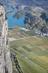
Monte Casale


The Monte Casale (1.632m) is situated near the famous 'Lake Toblino' (Trentino, Italy). Within it's high eastern rock wall is one of the longest fixed rope routes of the alps: Via Ferrata Che Guevara (1.200 climbing meters, 1.400 meters total difference of altitude, duration approx. 8 hours - without any breaks or foto stops. To be safe, calculate 12 hours, because you have to descent trough the shown forest in total darkness - only with light from your helmet lamp - at November time. NOTHING for beginners! Knowledge of the place is strongly recommended for night tours!)
~~~~~
Der Monte Casale (1.632m) liegt südwestlich des bekannten Toblino-Sees (Trentino, Italien). In seiner hohen Ostwand befindet sich einer der längsten Klettersteige der Alpen: die Via ferrata Che Guevara (1.200 Klettermeter, 1.400m Höhendifferenz incl. Zustieg, Gehzeit rund 8 Stunden - netto, ohne Pausen und Fotostopps. Um auf der sicheren Seite zu sein, muss man im November 12 Stunden einkalkulieren, weil man im Dunkeln - nur mit dem Licht der Helmlampe - durch den Wald absteigen muss, der im Bild zu sehen ist. Das ist NICHTS für Anfänger! Weder im Aufstieg, noch im Abstieg. Für Abstiege im Dunkeln ist gute Ortskenntnis unerlässlich! Gerade hier, wo man keine Hilfe erwarten kann. Nicht nachts, und nicht in der Nachsaison.)
~~~~~
Und so sieht's von oben aus:
Translate into English
~~~~~
Der Monte Casale (1.632m) liegt südwestlich des bekannten Toblino-Sees (Trentino, Italien). In seiner hohen Ostwand befindet sich einer der längsten Klettersteige der Alpen: die Via ferrata Che Guevara (1.200 Klettermeter, 1.400m Höhendifferenz incl. Zustieg, Gehzeit rund 8 Stunden - netto, ohne Pausen und Fotostopps. Um auf der sicheren Seite zu sein, muss man im November 12 Stunden einkalkulieren, weil man im Dunkeln - nur mit dem Licht der Helmlampe - durch den Wald absteigen muss, der im Bild zu sehen ist. Das ist NICHTS für Anfänger! Weder im Aufstieg, noch im Abstieg. Für Abstiege im Dunkeln ist gute Ortskenntnis unerlässlich! Gerade hier, wo man keine Hilfe erwarten kann. Nicht nachts, und nicht in der Nachsaison.)
~~~~~
Und so sieht's von oben aus:
Annemarie, , Ernest CH, and 36 other people have particularly liked this photo
- Keyboard shortcuts:
Jump to top
RSS feed- Latest comments - Subscribe to the comment feeds of this photo
- ipernity © 2007-2024
- Help & Contact
|
Club news
|
About ipernity
|
History |
ipernity Club & Prices |
Guide of good conduct
Donate | Group guidelines | Privacy policy | Terms of use | Statutes | In memoria -
Facebook
Twitter
Bergfex club has replied to Ulrich John clubBin gerade auf dem Sprung nach Deutschland und die nächsten Tage wenig aktiv.
Bis Montag!
Have a safe journey
Admired in ~ I ♥ Nature
Admired in:
www.ipernity.com/group/tolerance
Deine Warnung vor dem November ist gut verständlich, nachdem es jetzt um 17.00 Uhr leider schon dunkel wird. Mit dem Rad bin ich bei Sonnenuntergang noch akzeptabel schnell im Tal. Heimfahren kann man notfalls Aufstecklicht. Mittlerweile gibt es eine immer größere Fraktion von Nachteulen, die bewusst die Dunkelheit für Touren zu Fuß und zu Rad suchen, was sicher ein erhöhtes Risiko ist.
Wünsche euch einen schönen Tag!
www.facebook.com/ipernity
Bergfex club has replied to Moderator club" 100 % BELLA ITALIA -Italie -Italy - Italien "
www.ipernity.com/group/italia--italie
100% perfect
www.ipernity.com/group/centopercentoperfect100perfect
Sign-in to write a comment.