Pembrokeshire geology
Folder: Geology and Earth Science
Photos illustrating the geology of Pembrokeshire, west Wales.
Bullslaughter Bay
| |
|
Pembrokeshire Coast Path from St Govans to the Green Bridge of Wales
At Bullslaughter Bay, the Dinantian age Carboniferous Limestone Series has been eroded along a series of angular folds and fractures, forming a set of sea caves and sea stacks. The main structure is the Bullslaughter Bay syncline, the axis of which runs from near the caves in the centre of the photo, crossing the sandy beach towards the rocks on the right.
Some of the fractures are filled with orange-brown, angular brecciated sediment ('Collapse Breccia'), thought to be of Triassic age.
Bullslaughter Bay folds
| |
|
Pembrokeshire Coast Path from St Govans to the Green Bridge of Wales
Just west of Bullslaughter Bay, the Dinantian age Carboniferous Limestone Series has been eroded along a series of angular folds and fractures, forming a set of sea caves and sea stacks.
View west from Mewsford Point
| |
|
Pembrokeshire Coast Path from St Govans to the Green Bridge of Wales
A westerly view of the cliffs of Dinantian age Carboniferous Limestone Series, viewed from Mewsford Point on the south Pembrokeshire coast. In the centre of the photo is a series of angular folds, associated with the Bullslaughter Bay syncline (just out of sight behind the nearest cliff headland).
The flat landform topography represents the '200 foot platform' - a Tertiary age marine erosion surface.
View to St Govans Head
| |
|
Pembrokeshire Coast Path from St Govans to the Green Bridge of Wales
An easterly view of the cliffs of Dinantian age Carboniferous Limestone Series, viewed from St Govan's Chapel on the south Pembrokeshire coast. St Govan's Head is just to the right of centre. The rocks dip gently to seaward (south).
The flat landform topography represents the '200 foot platform' - a Tertiary age marine erosion surface.
Monkstone Point folds 2
| |
|
Coastal traverse and geology from Waterwynch to Saundersfoot, Pembrokeshire
At Monkstone Point, grey, channel-fill sandstones of the Namurian age 'Millstone Grit Series' have been folded into a complex anticline with subsidiary folds, thrusts, and bedding plane slips which accommodate the 'space problem' in the core of the main anticline.
These sandstones are probably the equivalent of the prominent overturned sandstone ribs at Trevayne Point at the south end of Monkstone Bay.
Monkstone Point folds 1
| |
|
Coastal traverse and geology from Waterwynch to Saundersfoot, Pembrokeshire
At Monkstone Point, grey, channel-fill sandstones of the Namurian age 'Millstone Grit Series' have been folded into a complex anticline with subsidiary folds, thrusts, and bedding plane slips which accommodate the 'space problem' in the core of the main anticline.
These sandstones are probably the equivalent of the prominent overturned sandstone ribs at Trevayne Point at the south end of Monkstone Bay.
Overturned bedding at Trevayne Point
| |
|
Coastal traverse and geology from Waterwynch to Saundersfoot, Pembrokeshire
The high cliff of Trevayne Point is just to the north of Lodge Valley beach. The rocks here are mostly pale grey sandstones of the Namurian age 'Millstone Grit Series' which have been folded into a nearly concentric anticline (on the left side of the cliff), with a near vertical, slightly overturned northern limb visible in the centre and right-hand side of the photo.
Trevayne Point anticline
| |
|
Coastal traverse and geology from Waterwynch to Saundersfoot, Pembrokeshire
The high cliff of Trevayne Point is just to the north of Lodge Valley beach. The rocks here are mostly pale grey sandstones of the Namurian age 'Millstone Grit Series' which have been folded into a nearly concentric anticline, with an overturned northern (right) limb.
Lodge Valley beach
| |
|
Coastal traverse and geology from Waterwynch to Saundersfoot, Pembrokeshire
The stream flowing through the Lodge Valley between Waterwynch and Monkstone Point ends in a small waterfall on to the beach. The rocks here are southerly dipping sandstones (brown and pale grey), shales (dark grey), and siltstones (mid-grey) in the lowest part of the Coal Measures. To the right of centre, the shales are thrusted over pale sandstones and dark shales which have been folded into a footwall anticline-syncline couplet.
Lodge Valley waterfall 4
| |
|
Coastal traverse and geology from Waterwynch to Saundersfoot, Pembrokeshire
The stream flowing through the Lodge Valley between Waterwynch and Monkstone Point ends in a small waterfall on to the beach. The rocks here are southerly dipping sandstones (brown), shales (dark grey), and siltstones (mid-grey) in the lowest part of the Coal Measures.
Lodge Valley waterfall 3
| |
|
Coastal traverse and geology from Waterwynch to Saundersfoot, Pembrokeshire
The stream flowing through the Lodge Valley between Waterwynch and Monkstone Point ends in a small waterfall on to the beach. The rocks here are southerly dipping sandstones (brown), shales (dark grey), and siltstones (mid-grey) in the lowest part of the Coal Measures.
Lodge Valley waterfall 2
| |
|
Coastal traverse and geology from Waterwynch to Saundersfoot, Pembrokeshire
The stream flowing through the Lodge Valley between Waterwynch and Monkstone Point ends in a small waterfall on to the beach. The rocks here are southerly dipping sandstones (brown), shales (dark grey), and siltstones (mid-grey) in the lowest part of the Coal Measures.
Lodge Valley waterfall 1
| |
|
Coastal traverse and geology from Waterwynch to Saundersfoot, Pembrokeshire
The stream flowing through the Lodge Valley between Waterwynch and Monkstone Point ends in a small waterfall on to the beach. The rocks here are southerly dipping sandstones (brown), shales (dark grey), and siltstones (mid-grey) in the lowest part of the Coal Measures.
Lodge Valley bedding plane descent to beach 4
| |
|
Coastal traverse and geology from Waterwynch to Saundersfoot, Pembrokeshire
A well-exposed sandstone bedding plane in Lower Coal Measures offers a relatively easy descent from the coast path to the beach at Lodge Valley, between Waterwynch and Monkstone Point. The stream flowing through the valley ends in a small waterfall on to the beach.
'Blue Lagoon' Abereiddi, Pembrokeshire
| |
|
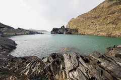
The 'Blue Lagoon' is the flooded lower section of an abandoned 'slate' quarry at Abereiddi bay, Pembrokeshire.
The rock is not true slate (a metamorphic rock) but thinly bedded black shales (Caerhys Shale) which span the Llanvirnian-Llandeilian junction in the Ordovician. On the right of the photo the quarry wall exposes the volcanic Abereiddi Tuff Member.
Abandoned 'slate' quarry, Abereiddi Bay, Pembrokes…
| |
|
Originally uploaded for the GuesswhereUK group. Photo has been replaced with slightly more extensive, uncropped version.
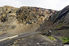
This is the back-wall of the abandoned 'slate' quarry, the flooded section of which is now the Blue Lagoon at Abereiddi bay, Pembrokeshire.
The rock is not true slate (a metamorphic rock) but thinly bedded black shales (Caerhys Shale) which span the Llanvirnian-Llandeilian junction in the Ordovician. Certain bedding planes towards the right-hand side are particularly rich in the graptolite zone fossil Didymograptus murchisoni .
Thousands of people each year see this, either walking past it or attending diving or coasteering (horrible word!) events in the Blue Lagoon.
Pwlldawnau and Penbwchdy, Pembrokeshire
| |
|
|
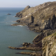
The little inlet of Pwlldawnau and the headland Penbwchdy, viewed from adjacent to the Pembrokeshire Coastal Path at National grid ref. SM 8808 3692 (a nice place for a sandwich).
The prominent pale rock horizon consists of sandstone and conglomerate at the base of the Ordovician age Ogof Hen Formation. This rests unconformably on the underlying shales of the Cambrian age Lingula Flags. The far headland of Penbwchdy is comprised of a microtonalite sill, an igneous intrusion. If you zoom in on the photo you can see near-vertical columnar cooling joints in the sill.
Lichen at Traeth Llyfn in the late afternoon sun
| |
|
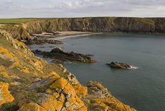
Traeth Llyfn is an attractive west-facing sandy beach on the north Pembrokeshire coast, viewed here looking south-east from the north headland in the late afternoon sun when just about everyone else had gone in for tea.
The cliffs are mostly in the dark grey Aber Mawr Shale Formation (Ordovician), steeply dipping to vertically bedded, with a few thin tuff bands (volcanic ash bands). There are igneous intrusions at the north end of Traeth Llyfn including a dolerite/gabbro sill which forms the un-named north headland to the bay (here).
Access to Traeth Llyfn is by boat or by a bracing walk along the cliff top path from Abereiddi Bay 3/4 of a mile away. There are no facilities here and no vehicular access. A lovely place...
Jump to top
RSS feed- Latest items - Subscribe to the latest items added to this album
- ipernity © 2007-2024
- Help & Contact
|
Club news
|
About ipernity
|
History |
ipernity Club & Prices |
Guide of good conduct
Donate | Group guidelines | Privacy policy | Terms of use | Statutes | In memoria -
Facebook
Twitter


