Pembrokeshire geology
Folder: Geology and Earth Science
Photos illustrating the geology of Pembrokeshire, west Wales.
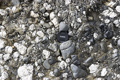
Conglomerate at Gravel Bay: close-up view 1
| |
|
Freshwater West, Gravel Bay and East Pickard Bay
Close-up view of a conglomerate in the Freshwater East Formation (note name) at Gravel Bay, situated at the northern end of the large Freshwater West bay in south Pembrokeshire. The lens cap is 72 mm in diameter.
The Freshwater East Formation marks the beginning of 'Old Red Sandstone' type of sediments, formerly believed to be at the base of the Devonian, but now assigned to the uppermost Silurian. The pebbles and cobbles in the conglomerates mostly consist of white vein quartz and quartzite, grey sandstones and darker sitstones. These were depositied in an alluvial fan settting on a shallow floodplain in increasingly arid conditions.
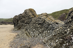
Conglomerates at Gravel Bay
| |
|
|
|
Freshwater West, Gravel Bay and East Pickard Bay
Massive conglomerates and grey sandstones dipping steeply to the north (right) of the Freshwater East Formation (note name) at Gravel Bay, situated at the northern end of the large Freshwater West bay in south Pembrokeshire. The walking stick is 0.9 m long.
The Freshwater East Formation marks the beginning of 'Old Red Sandstone' type of sediments, formerly believed to be at the base of the Devonian, but now assigned to the uppermost Silurian. The pebbles and cobbles in the conglomerates mostly consist of white vein quartz and quartzite, grey sandstones and darker sitstones. These were depositied in an alluvial fan settting on a shallow floodplain in increasingly arid conditions.
Little Settlands - inverted thin coals and disturb…
| |
|
Structural geology of Little Haven and The Settlands
The cliffs from Little Haven to Broad Haven (and northward) display a spectacular range of geological structures, folding, faulting and thrusting, mainly in the Lower Coal Measures. The relatively weak mudstone and shale-dominated sequences show much incompetent deformation: tight, thrusted and overturned folds, in contrast to the thicker, stronger, sandstones which have formed relatively open and concentric folds.
Immediately north of The Rain headland is a small embayment: 'Little Settlands'. Here, a chaotic looking series of disturbed bedding and downward-facing small folds are in contact with a thin coal. The whole sequence is inverted, the inversion being a continuation of the overturned structure seen on The Rain and the northern end of the main Settlands bay.
The coal is completely inverted ('up' is to down to the left). Three thin leaves of coal are visible here. Furthest to the left is the true upper leaf approx. 8 cm thick. This is underlain by pale grey seatearth (behind the walking stick), then another two thin bands of coal one by the stick handle and another beyond that. There appears to be a shear plane to the right of the stick handle; the coal leaf which uppermost in the photo may be a structural duplication repeat of the 8 cm coal leaf. See notes.
The stick is 90 cm long.
Little Settlands - incompetent deformation 2
| |
|
Structural geology of Little Haven and The Settlands
The cliffs from Little Haven to Broad Haven (and northward) display a spectacular range of geological structures, folding, faulting and thrusting, mainly in the Lower Coal Measures. The relatively weak mudstone and shale-dominated sequences show much incompetent deformation: tight, thrusted and overturned folds, in contrast to the thicker, stronger, sandstones which have formed relatively open and concentric folds.
Immediately north of The Rain headland is a small embayment: 'Little Settlands'. Here, a chaotic looking series of disturbed bedding and downward-facing small folds are in contact with a thin coal. The whole sequence is inverted, the inversion being a continuation of the overturned structure seen on The Rain and the northern end of the main Settlands bay.
Downward-facing means that the way-up, younging direction, of the folds is downwards, rather than the normal upwards. The evidence for the way up is provided by small scale (too small to be seen clearly in this photo) sedimentary slump and load casts on the bases of sandy layers within the predominantly shale and mudstone sequence. The inverted folds are thought to have been initiated immediately prior to the main folding and thrusting event.
This shows a closer view of the downward-facing fold in the previous photo. The younging direction is down towards the lower right, so the structure spanned by the walking stick is actually an overturned and inverted syncline.
The stick is 90 cm long.
Little Settlands - incompetent deformation 1
| |
|
Structural geology of Little Haven and The Settlands
The cliffs from Little Haven to Broad Haven (and northward) display a spectacular range of geological structures, folding, faulting and thrusting, mainly in the Lower Coal Measures. The relatively weak mudstone and shale-dominated sequences show much incompetent deformation: tight, thrusted and overturned folds, in contrast to the thicker, stronger, sandstones which have formed relatively open and concentric folds.
Immediately north of The Rain headland is a small embayment: 'Little Settlands'. Here, a chaotic looking series of disturbed bedding and downward-facing small folds are in contact with a thin coal. The whole sequence is inverted, the inversion being a continuation of the overturned structure seen on The Rain and the northern end of the main Settlands bay, e.g. on the left in the previous photo here:
Downward-facing means that the way-up, younging direction, of the folds is downwards, rather than the normal upwards. So the structure at the lower right (see note) which looks like an overturned anticline is actually an inverted syncline. The evidence for the way up is provided by small scale (too small to be seen clearly in this photo) sedimentary slump and load casts on the bases of sandy layers within the predominantly shale and mudstone sequence. The inverted folds are thought to have been initiated immediately prior to the main folding and thrusting event.
The coal is completely inverted ('up' is to down to the left) and separated from the inverted folds by a prominent shear plane just below the bottom of the walking stick and running up towards the upper left.
The stick is 90 cm long.
Little Haven - The Settlands; detail of overturned…
| |
|
|
Structural geology of Little Haven and The Settlands
The cliffs from Little Haven to Broad Haven (and northward) display a spectacular range of geological structures, folding, faulting and thrusting, mainly in the Lower Coal Measures. The relatively weak mudstone and shale-dominated sequences show much incompetent deformation: tight, thrusted and overturned folds, in contrast to the thicker, stronger, sandstones which have formed relatively open and concentric folds.
This is a close-up view of the prominent overturned, nearly recumbent, chevron-style anticline at the northern end of The Settlands. The relatively weak mudstone and shale sequence has deformed incompetently, with some thickening in the hinge zone.The dark shale bed just below the centre of the photo is at the horizon of the Amman Marine Band.
The overturned northern limb of the fold is separated from the nearly horizontal upper limb by a near-horizontal thrust. Below this thrust, disturbed, separate, repeated portions of the hinge zone are visible, one of which has developed axial planar cleavage in the grey seatearth with brown ironstone bands and nodules.
Above the anticline, another significant, higher, thrust has carried more sandy beds over the top.
See notes for individual descriptions of areas on the photo.
Little Haven - The Settlands; detail of incompeten…
| |
|
|
Structural geology of Little Haven and The Settlands
The cliffs from Little Haven to Broad Haven (and northward) display a spectacular range of geological structures, folding, faulting and thrusting, mainly in the Lower Coal Measures. The relatively weak mudstone and shale-dominated sequences show much incompetent deformation: tight, thrusted and overturned folds, in contrast to the thicker, stronger, sandstones which have formed relatively open and concentric folds.
This is a closer view of the complexly folded and thrusted sequence in the central part of the The Settlands. The relatively weak mudstone and shale sequence has deformed incompetently.
In the centre, an anticline with a vertical/slightly overturned northern limb is separated by a near-horizontal thrust from the gently dipping shales just above the beach pebbles.
To the right, a curved slice of siltstones/thin sandstones is itself thrusted over the horizontal thrust. The dark shale bed in the centre of the photo is approximately at the horizon of the Amman Marine Band, which can be followed, despite the structural complexity, northwards (left) to The Rain headland.
See notes for individual descriptions of areas on the photo.
Little Haven - The Settlands; detail of incompeten…
| |
|
Structural geology of Little Haven and The Settlands
The cliffs from Little Haven to Broad Haven (and northward) display a spectacular range of geological structures, folding, faulting and thrusting, mainly in the Lower Coal Measures. The relatively weak mudstone and shale-dominated sequences show much incompetent deformation: tight, thrusted and overturned folds, in contrast to the thicker, stronger, sandstones which have formed relatively open and concentric folds.
This is a closer view of the complexly folded and thrusted sequence in the central part of the The Settlands. The reatively weak mudstone and shale sequence has deformed incompetently, in stark contrast to the small anticline a few metres to the south (right) in the previous photo. The dark shale bed in the centre of the photo is approximately at the horizon of the Amman Marine Band, which can be followed, despite the structural complexity, northwards (left) to The Rain headland.
See notes for individual descriptions of areas on the photo.
Little Haven - The Settlands; detail of southern a…
| |
|
Structural geology of Little Haven and The Settlands
The cliffs from Little Haven to Broad Haven (and northward) display a spectacular range of geological structures, folding, faulting and thrusting, mainly in the Lower Coal Measures. The relatively weak mudstone and shale-dominated sequences show much incompetent deformation: tight, thrusted and overturned folds, in contrast to the thicker, stronger, sandstones which have formed relatively open and concentric folds.
This is a closer view of the small anticline at the southern end of The Settlands. This open, concentric fold is comprised mostly of strong, competent sandstones in the core, overlain by dark shaly beds. The sandsones may possibly be correlated with the sandstones in the large and well-developed Fox Hole anticline situated immediately to the south (right), althought there is a significant fault between the two features and the correlation is by no means certain.
Little Haven - The Settlands; recumbent fold, thru…
| |
|
|
Structural geology of Little Haven and The Settlands
The cliffs from Little Haven to Broad Haven (and northward) display a spectacular range of geological structures, folding, faulting and thrusting, mainly in the Lower Coal Measures. The relatively weak mudstone and shale-dominated sequences show much incompetent deformation: tight, thrusted and overturned folds, in contrast to the thicker, stronger, sandstones which have formed relatively open and concentric folds.
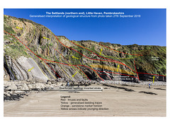
The cliffs at the east end of The Settlands bay display a series of complexly thrusted, folded and faulted Lower Coal Measures rocks. The folds are overturned to the north, becoming nearly recumbent (low-angle fold axes) near the northern headland, known as 'The Rain', seen here on the left. The complexity of the folding is mostly due to the predominance of weak mudstones and shales which undergo incompetent deformation, in contrast to the open folding in the strong sandstone Fox Hole anticline in previous photos, and in the less disturbed but overturned sandstone sequence on the left of this photo.
The principal structure in the central region of the photo is a nearly recumbent fold with several associated thrusts. There are two main thrusts and several smaller thrust splays which result in repetition of the strata, mainly around the horizon of the Amman Marine Band. Yellow arrows indicate the 'way up', younging direction, of the beds.
Interpretation linework carried out using Affinity Designer software.
More detailed view here:
This is a generalised geological interpretation of the previous photo here:
Little Haven - The Settlands; recumbent fold, thru…
| |
|
|
Structural geology of Little Haven and The Settlands
The cliffs from Little Haven to Broad Haven (and northward) display a spectacular range of geological structures, folding, faulting and thrusting, mainly in the Lower Coal Measures. The relatively weak mudstone and shale-dominated sequences show much incompetent deformation: tight, thrusted and overturned folds, in contrast to the thicker, stronger, sandstones which have formed relatively open and concentric folds.
The cliffs at the east end of The Settlands bay display a series of complexly thrusted, folded and faulted Lower Coal Measures rocks. The folds are overturned to the north, becoming nearly recumbent (low-angle fold axes) near the northern headland, known as 'The Rain', seen here on the left. The complexity of the folding is mostly due to the predominance of weak mudstones and shales which undergo incompetent deformation, in contrast to the open folding in the strong sandstone Fox Hole anticline in previous photos, and in the less disturbed but overturned sandstone sequence on the left of this photo.
The principal structure in the central region of the photo is a nearly recumbent fold with several associated thrusts. There are two main thrusts and several smaller thrust splays which result in repetition of the strata, mainly around the horizon of the Amman Marine Band.
More detailed view here:
A generalised geological interpretation is given in the adjacent photo here:
Little Haven - The Settlands panorama - geological…
| |
|
Structural geology of Little Haven and The Settlands
The cliffs from Little Haven to Broad Haven (and northward) display a spectacular range of geological structures, folding, faulting and thrusting, mainly in the Lower Coal Measures. The relatively weak mudstone and shale-dominated sequences show much incompetent deformation: tight, thrusted and overturned folds, in contrast to the thicker, stronger, sandstones which have formed relatively open and concentric folds.
The cliffs at the east end of the The Settlands bay display a series of complexly thrusted, folded and faulted Lower Coal Measures rocks. The folds are overturned to the north, becoming nearly recumbent (low-angle fold axes) near the northern headland, known as 'The Rain'. The complexity of the folding is mostly due to the predominance of weak mudstones and shales which undergo incompetent deformation, in contrast to the open folding in the strong sandstone Fox Hole anticline in previous photos.
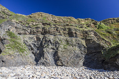
This is a generalised geological interpretation of the visible structures in the previous photo:
www.ipernity.com/doc/earthwatcher/49995364
There are two main thrusts and several smaller thrust splays which result in repetition of the strata, mainly around the horizon of the Amman Marine Band. The weaker mud-rich rocks have deformed and thickened into the axial crests of the folds and usually display a degree of axial planar cleavage. The folds are mainly overturned anticlines; the synclines have been cut out by thrusting. The small anticline visible on the right may possibly be comprised of the uppermost beds of the Fox Hole sandstone, but the correlation is very uncertain.
See notes for links to detailed views.
The background photo is a panoramic view consisting of three landscape photos stiched together in Affinity Photo sofware. Interpretation linework carried out using Affinity Designer software.
Little Haven - The Settlands panorama
| |
|
Structural geology of Little Haven and The Settlands
The cliffs from Little Haven to Broad Haven (and northward) display a spectacular range of geological structures, folding, faulting and thrusting, mainly in the Lower Coal Measures. The relatively weak mudstone and shale-dominated sequences show much incompetent deformation: tight, thrusted and overturned folds, in contrast to the thicker, stronger, sandstones which have formed relatively open and concentric folds.
The cliffs at the east end of the The Settlands bay display a series of complexly thrusted, folded and faulted Lower Coal Measures rocks. The folds are overturned to the north, becoming nearly recumbent (low-angle fold axes) near the northern headland, known as 'The Rain'. The complexity of the folding is mostly due to the predominance of weak mudstones and shales which undergo incompetent deformation, in contrast to the open folding in the strong sandstone Fox Hole anticline in previous photos.
There are two main thrusts and several smaller thrust splays which result in repetition of the strata, mainly around the horizon of the Amman Marine Band. The weaker mud-rich rocks have deformed and thickened into the axial crests of the folds and usually display a degree of axial planar cleavage. The folds are mainly overturned anticlines; the synclines have been cut out by thrusting. The small anticline visible on the right may possibly be comprised of the uppermost beds of the Fox Hole sandstone, but the correlation is very uncertain.
See notes for links to detailed views.
The adjacent photo gives a geological interpretation of the visible structures.
www.ipernity.com/doc/earthwatcher/49998924
This photo is a panoramic view consisting of three landscape photos stiched together in Affinity Photo sofware.
Fox Hole Anticline - northern limb with mine adit
| |
|
Structural geology of Little Haven and The Settlands
The cliffs from Little Haven to Broad Haven (and northward) display a spectacular range of geological structures, folding, faulting and thrusting, mainly in the Lower Coal Measures. The relatively weak mudstone and shale-dominated sequences show much incompetent deformation: tight, thrusted and overturned folds, in contrast to the thicker, stronger, sandstones which have formed relatively open and concentric folds.
The northern limb of the Fox Hole anticline forms the southern headland of The Settlands bay. The style of folding is open and concentric, largely due to the thick (approx 70 m in total) and competent (strong) nature of the sandstone of which it is comprised. At the western end of the headland the bedding dips at about 30° to the north, but this steepens along its length to become near-vertical at the eastern end of the headland.
This is a view from The Settlands looking head-on at the steeply dipping bedding surfaces. The bedding is cut by nurmerous joints (fractures). Just left of centre is a fenced-off mine entrance a few metres above beach level. This is thought to be a former drainage level to dewater coal mine workings, possibly in the core of the anticline and perhaps further inland.
Fox Hole Anticline - northern limb jointing with c…
| |
|
|
|
Structural geology of Little Haven and The Settlands
The cliffs from Little Haven to Broad Haven (and northward) display a spectacular range of geological structures, folding, faulting and thrusting, mainly in the Lower Coal Measures. The relatively weak mudstone and shale-dominated sequences show much incompetent deformation: tight, thrusted and overturned folds, in contrast to the thicker, stronger, sandstones which have formed relatively open and concentric folds.
The northern limb of the Fox Hole anticline forms the southern headland of The Settlands bay. The style of folding is open and concentric, largely due to the thick (approx 70 m in total) and competent (strong) nature of the sandstone of which it is comprised. At the western end of the headland the bedding dips at about 30° to the north, but this steepens along its length to become near-vertical at the eastern end of the headland.
This is a view looking head-on at the steeply dipping bedding surfaces. The bedding is cut by nurmerous joints (fractures) which in this case has been enlarged by erosion to form a shallow sea cave at beach level. Someone has lit a candle on a rack inside the cave. Perhaps a memorial to a loved one?
Fox Hole Anticline - northern limb 3
| |
|
|
Structural geology of Little Haven and The Settlands
The cliffs from Little Haven to Broad Haven (and northward) display a spectacular range of geological structures, folding, faulting and thrusting, mainly in the Lower Coal Measures. The relatively weak mudstone and shale-dominated sequences show much incompetent deformation: tight, thrusted and overturned folds, in contrast to the thicker, stronger, sandstones which have formed relatively open and concentric folds.
The northern limb of the Fox Hole anticline forms the southern headland of The Settlands bay. The style of folding is open and concentric, largely due to the thick (approx 70 m in total) and competent (strong) nature of the sandstone of which it is comprised. At the western end of the headland the bedding dips at about 30° to the north, but this steepens along its length to become near-vertical at the far end of the headland as seen here, where the anticline is abruptly terminated by a fault (running more or less parallel to the shadow edge).
The southerly (right) dipping rocks at the far left are on the southern limb of a small anticline and may possibly be comprised of the uppermost beds of the Fox Hole sandstone, but the correlation is very uncertain.
Folding, faulting and thrusting make determination of the exact stratigraphic correlation of the Fox Hole sandstone difficult, but it is reasonably clear that this is the lowest stratigraphic unit in the Little Haven area and is well down in the Lower Coal Measures sequence.
Fox Hole Anticline - northern limb 2
| |
|
Structural geology of Little Haven and The Settlands
The cliffs from Little Haven to Broad Haven (and northward) display a spectacular range of geological structures, folding, faulting and thrusting, mainly in the Lower Coal Measures. The relatively weak mudstone and shale-dominated sequences show much incompetent deformation: tight, thrusted and overturned folds, in contrast to the thicker, stronger, sandstones which have formed relatively open and concentric folds.
The northern limb of the Fox Hole anticline forms the southern headland of The Settlands bay. The style of folding is open and concentric, largely due to the thick (approx 70 m in total) and competent (strong) nature of the sandstone of which it is comprised. At the western end of the headland (nearest in view) the bedding dips at about 30° to the north, but this steepens along its length to become near-vertical at the far end of the headland, where the anticline is abruptly terminated by a fault.
The small anticline visible at the far left may possibly be comprised of the uppermost beds of the Fox Hole sandstone, but the correlation is very uncertain.
Folding, faulting and thrusting make determination of the exact stratigraphic correlation of the Fox Hole sandstone difficult, but it is reasonably clear that this is the lowest stratigraphic unit in the Little Haven area and is well down in the Lower Coal Measures sequence.
Fox Hole Anticline - northern limb
| |
|
|
|
Structural geology of Little Haven and The Settlands
The cliffs from Little Haven to Broad Haven (and northward) display a spectacular range of geological structures, folding, faulting and thrusting, mainly in the Lower Coal Measures. The relatively weak mudstone and shale-dominated sequences show much incompetent deformation: tight, thrusted and overturned folds, in contrast to the thicker, stronger, sandstones which have formed relatively open and concentric folds.
This is a close up view of the northern limb of the Fox Hole anticline taken from beach level. The style of folding is open and concentric, largely due to the thick (approx 70 m in total) and competent (strong) nature of the sandstone of which it is comprised.
The sandstone displays a number of sedimentary features, including cross-bedding and channel erosion (visible just above and to the right of centre), formed by deposition in a high-energy delta distributary channel setting. Restoring the anticline to its 'unfolded' condition, these sedimentary structures then indicate a general current flow direction from south-west to north-east.
Folding, faulting and thrusting make determination of the exact stratigraphic correlation of the Fox Hole sandstone difficult, but it is reasonably clear that this is the lowest stratigraphic unit in the Little Haven area and is well down in the Lower Coal Measures sequence.
Jump to top
RSS feed- Latest items - Subscribe to the latest items added to this album
- ipernity © 2007-2024
- Help & Contact
|
Club news
|
About ipernity
|
History |
ipernity Club & Prices |
Guide of good conduct
Donate | Group guidelines | Privacy policy | Terms of use | Statutes | In memoria -
Facebook
Twitter

