MJ Maccardini (trailerfullofpix)'s photos with the keyword: map
IMG 3459-001-Frieze Sculpture 2024 Map
| 03 Mar 2025 |
|
Photos follow, with info on each in the PiPs. I try to go to Frieze Sculpture every year (I'll miss 2025, however). I wasn't impressed by the 2024 sculptures, but it's always enjoyable to amble around Regent's Park looking at them.
PXL 20240927 105223159-001-Tunnel Network
| 21 Jan 2025 |
|
|
|
The "caves" are a network of 22 miles of human-dug tunnels and caverns, some created as early as the 13th century. Initially for mining chalk and flint, they were used in the 20th century as munitions storage in WW1, a mushroom farm, extensive bomb shelters in WW2 housing 15,000 people, a music venue and for tv and film location shooting.
IMG 2851-001-Bronze Map
| 15 Dec 2024 |
|
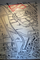
This is in Aragon Park, set back a bit from the river. I couldn't find any explanation of it, but I wonder if it was done by Michael Rizzello. The raised structures seem to be the docks, St Nicholas Deptford and the Royal Naval College in Greenwich.
IMG 2676-001-Highgate Visitor Map
IMG 2671-001-Street art by mind.tha.cat
IMG 1257-001-Clarken Well Map
IMG 0984-001-FriezeSculpture2023
IMG 9813-001-Undercroft Grave Slabs Map
| 05 Jul 2023 |
|
Diagram of the location of the grave slabs under the chapel, Lincoln's Inn.
IMG 6752-001-Map Mobile by Mona Hatoum 2
IMG 6755-001-Map Mobile by Mona Hatoum 1
IMG 5145-001-D Company Memorial
| 29 Sep 2018 |
|
Peadar Whelan, our walking tour guide from Coiste , an organization of/for former IRA prisoners. At the rear of the Garden of Remembrance in the Falls Road is a monument in memory of the volunteers of D Company who died of natural causes. The mural behind shows a map of how the area looked at the time of the curfew of 1970, when dozens of little streets intersected throughout the area, making it possible for people to run through from one street to another when fleeing the police or the army. Soon after, the British government undertook "slum clearance" and knocked down swaths of housing, replacing it with council housing and a new street pattern of many dead ends without the through streets.
Paddington Cemetery Map
| 03 Jan 2016 |
|
It was laid out by Thomas Little who was also responsible for Nunhead Cemetery. Paddington Old Cemetery, Willesden Lane, Queen's Park/Kilburn www.londongardensonline.org.uk/gardens-online-record.asp?ID=BRE023
Churchyard Gardens Sign
Queens Park Map
| 16 Mar 2014 |
|
Painted on a brick wall in the school yard, Salusbury Road Primary School, Queens Park. "Willesden Lane Cemetry" is actually Paddington Old Cemetery, which I haven't poked around in but I mean to do.
Maps & Instructions
| 15 Oct 2006 |
|
Stuff waiting for me upon my arrival. The cleaning lady let me in when my key didn't work in the lock. Then I went out and couldn't get back in when it poured again.
See where this picture was taken. [?]
St John's Lodge Garden
| 25 Sep 2008 |
|
The secret garden in Regent's Park.
See where this picture was taken. [?]
Bliar
| 20 Oct 2008 |
|
by Cartrain. Blackall Street, Shoreditch.
See where this picture was taken. [?]
European Starlings
| 15 Oct 2009 |
|
|
|
These are bold little blighters. They jumped right up on my table and stared at me as I was eating a croissant at the tea hut in Kensington Gardens.
See where this picture was taken. [?]
Jump to top
RSS feed- MJ Maccardini (trailerfullofpix)'s latest photos with "map" - Photos
- ipernity © 2007-2025
- Help & Contact
|
Club news
|
About ipernity
|
History |
ipernity Club & Prices |
Guide of good conduct
Donate | Group guidelines | Privacy policy | Terms of use | Statutes | In memoria -
Facebook
Twitter


