slgwv's photos with the keyword: valley
From the Abert Rim--
| 17 Jul 2017 |
|
|
|
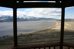
Looking northwest from a point, accessible to vehicles, that evidently is a popular hang-gliding takeoff spot. The Abert Rim is a large fault scarp, related to Basin and Range crustal extension, that extends some 30 miles (50 km) roughly north-south in south-central Oregon, and stands roughly 2500 ft (~760 m) above the valley floor below. We're near the southern end here. US highway 395 runs more or less horizontally across the valley below, and a cluster of trees marks Valley Falls (note), where Oregon State Route 31 takes off to run northwesterly. Summer Lake (or rather, the playa on the east side thereof) is barely visible in the far distance (note), below Winter Ridge, another fault scarp.
The Chewaucan River flows out of the mountains (Gearhart Mtns) to the left and crosses diagonally in the middle distance, eventually ending in saline Abert Lake (hidden behind the near scarp to the right). The body of water at center-right is a reservoir that stores water from the Chewaucan before it enters the lake. The inset on the right is a close up of this reservoir.
"Abert" (AY-bert) looks like a misspelling of "Albert," but the name comes from John James Abert and his son James William Abert. Both were members of the Corps of Topographical Engineers, which carried out explorations in the West before the US Civil War. The younger Abert was a member of John C. Fremont's expedition which came thru this area in 1843.
Lamoille Canyon
| 30 Sep 2016 |
|
|
|
Ruby Mountains, northeastern Nevada. Not the sort of scene that shouts "Nevada" to most folks! ;) The Ruby Mountains were glaciated in the Pleistocene, Lamoille Canyon being a spectacular example of a glacial canyon with associated landforms (hanging valleys, cirque lakes, etc.) It's often called "Nevada's Yosemite."
Reese River Butte
| 21 Sep 2012 |
|
Toiyable Range in the background; Arc Dome is the peak just to the right of directly over the butte. This unprepossessing hillock, out in the middle of the Reese River Valley, is the survey turning point for the north-northwestern corner of Nye County. Must've been easy to identify back in the 19th century.
Washoe Lake
Big Valley
| 02 Aug 2011 |
|
Granite Springs Valley, looking north. Bluewing Mountains on the skyline to the left.
Dayton Valley
| 22 May 2012 |
|
From the summit of Mt. Rawe, the highest point at the northern end of the Pine Nut Mtns. It wasn't too far from the road, but the trek involved some serious bushwhacking thru mountain mahogany thickets!
Looking slightly northwest. Carson Range on the skyline, with the sporadic snow caps; Virginia Range in the middle distance.
Washoe Lake State Park
Washoe Lake
| 26 Apr 2011 |
|
Washoe Lake
Jump to top
RSS feed- slgwv's latest photos with "valley" - Photos
- ipernity © 2007-2025
- Help & Contact
|
Club news
|
About ipernity
|
History |
ipernity Club & Prices |
Guide of good conduct
Donate | Group guidelines | Privacy policy | Terms of use | Statutes | In memoria -
Facebook
Twitter


