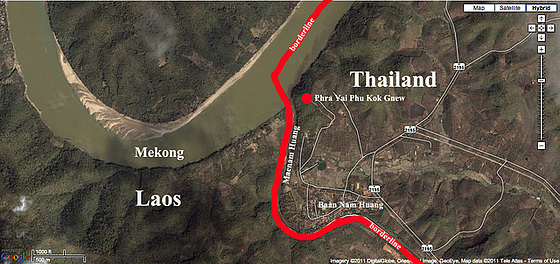
Phra Yai Phu Kok Gnew
Baan Khok Yai
Unsafe oncoming traffic
I'm up to my neck in the water
Evacuation by the Royal Thai Military
Phone booths half a meter under water
A bicycle rider tries to find his way
Capture out the front shield
Sena Nikhom intersection
View down the flyover
Down the flyover on Phaholyotin highway
Phaholyotin national highway Sena Nikhom
Lucky to reach our home
The flood comes in our Soi
The flood comes in our Soi
Mobile pumpstation full in action
Outside the Phaholyotin highway
Pickup car with radiator grill protection
Our garden
Water at the highest level
Teddy our friend from Liberia
Level rising an other 20 cm
Neighbours garden
Buddha watching down the hill
Maenam Loei mouths into the Mekong
Maenam Loei
Evening setting at the Mekong riverside
At the riverside of the Mekong
At the mouth of the Menam Loei river
Takhian tree spirit
Maenam Loei
Ton Takhian spirit
6.8 Mill. bats leaving the Pha Yaa cave
Pha Yaa cave mountain
Cross-country through the province Loei
Landscape along the way to the bats cave
Rotibaker in Loei city
Loei city main road Charoen-Rat
Holy chedi beside the temples building
Abbot of the monastery
Look inside a monks accommodation
Buddha images and a dignitary wax work
Abbot in front of his accommodation
Compound of monks accommodations
Location
Lat, Lng:
You can copy the above to your favourite mapping app.
Address: unknown
You can copy the above to your favourite mapping app.
Address: unknown
See also...
Keywords
Authorizations, license
-
Visible by: Everyone -
All rights reserved
- Photo replaced on 22 May 2020
-
4 570 visits
View far into Laos and the Mekong river


Kok Gnew Mountain is located where the Mekong River first meets the Isaan region of northeast. A second river from Laos called Maenam Huang ends by converging with the Mekong to produce a two-colored stream of water in the river; one darker than the other. The Maenam Huang is a natural border between Thailand and Laos. The Mekong flews full in Laos and does not be the border line between Thailand and Laos for about 550 km.
From the top of the mountain it was a superb view of the river below and sunsets.

From the top of the mountain it was a superb view of the river below and sunsets.

Maria, , Berny and 2 other people have particularly liked this photo
- Keyboard shortcuts:
Jump to top
RSS feed- Latest comments - Subscribe to the comment feeds of this photo
- ipernity © 2007-2025
- Help & Contact
|
Club news
|
About ipernity
|
History |
ipernity Club & Prices |
Guide of good conduct
Donate | Group guidelines | Privacy policy | Terms of use | Statutes | In memoria -
Facebook
Twitter

The Isaan in north east of Thailand has 20 provinces and is the "breadbasket" of all the Thai citizen.
Amnat Charoen, Buriram, Chaiyaphum, Kalasin, Khon Kaen, Loei, Maha Sarakham, Mukdahan, Nakhon Phanom, Nakhon Ratchasima, Nongbua Lamphu, Nong Khai, Roi Et, Sakon Nakhon, Sisaket, Surin, Ubon Ratchathani, Udon Thani, Yasothon and Bueng Kan.
Most travelers who came to visit Thailand get liked this part of the nation as one of the unspoiled and still origin part of this country of smile, where people smile in honest meaning.
Loei is the province I visited many times. In my opinion Loei is the most beautiful one and many people call it SWITZERLOI.
Sign-in to write a comment.