1/1900 • f/2.6 • 3.7 mm • ISO 80 •
SAMSUNG GT-I9300
Location
Lat, Lng:
Lat, Lng:
You can copy the above to your favourite mapping app.
Address: unknown
Lat, Lng:
You can copy the above to your favourite mapping app.
Address: unknown
See also...
See more...Keywords
Authorizations, license
-
Visible by: Everyone -
All rights reserved
-
842 visits
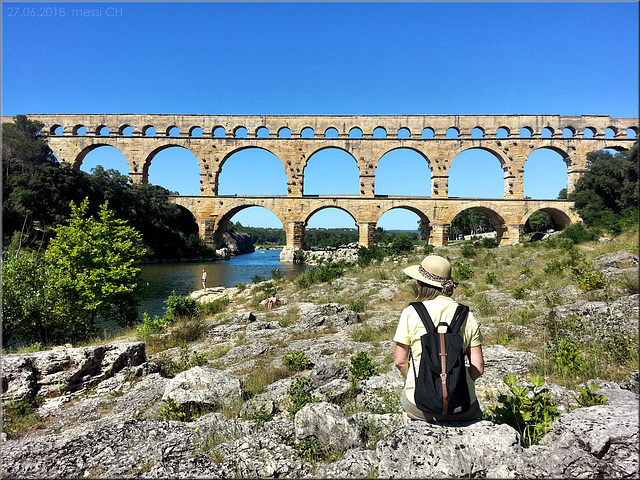
Pont du Gard


Provence – Pont du Gard
The Pont du Gard is an ancient Roman aqueduct that crosses the Gardon River near the town of Vers-Pont-du-Gard in southern France.
The Pont du Gard is part of an aqueduct that leads across the River Gard and then supplied the town of Nîmes with fresh drinking water from the sources at Uzès.
The height difference between the source and the city of Nîmes was just 17 meters. This results in a slope of 34 centimeters per kilometer! And here lies the ingenuity of the entire structure: over the total length of 50 km, this slight gradient was exactly maintained and implemented. In the process, mountains were bypassed or pierced with tunnels, and river valleys with bridges were overcome without departing from the slight inclination.
The Pont du Gard, built as three tiers of archways to bring water to the city of Nîmes, is the highest of all elevated Roman aqueducts, and one of the best preserved. It was added to UNESCO's list of World Heritage Sites in 1985 because of its historical importance.
The aqueduct is built in three levels:
- Lower level: 6 arches, 142 m long, 6 m wide, 22 m high
- Middle level: 11 arches, 242 m long, 4 m wide, 20 m high
- Upper level: 35 arches, 275 m long, 3 m wide, 7 m high
Total height: 49 m
Total lenght: 275 m
Built: around 40 – 60 AD
=> Pont du Gard, Deutsch
(43.94643, 04.53454); [70°] – handy shot
E. Adam G., Walter 7.8.1956, Karen's Place, Marco F. Delminho and 19 other people have particularly liked this photo
- Keyboard shortcuts:
Jump to top
RSS feed- Latest comments - Subscribe to the comment feeds of this photo
- ipernity © 2007-2024
- Help & Contact
|
Club news
|
About ipernity
|
History |
ipernity Club & Prices |
Guide of good conduct
Donate | Group guidelines | Privacy policy | Terms of use | Statutes | In memoria -
Facebook
Twitter

Yes, it's a lovely place! And not to forget: it was incredible hot! Around 32°C (90°F). :-)
Sign-in to write a comment.