View south east over Dore and Totley from Lady Can…
View west over Limb Valley from Lady Canning's Pla…
Houndkirk Road looking south west
Houndkirk Hill north-west escarpment
Path to Houndkirk Hill
God's Spring
Looking north over Houndkirk Moor
Scarp edge of Houndkirk Hill
Summit rocks of Houndkirk Hill 1
Summit rocks of Houndkirk Hill 2
View north-east from Houndkirk Hill escarpment
Summit of Houndkirk Hill looking NE
Summit of Houndkirk Hill looking south
Summit of Houndkirk Hill looking E over Beauchief
Summit of Houndkirk Hill looking NNE
Houndkirk Hill and guidepost view north
Summit rocks of Houndkirk Edge looking NE to Hound…
Shelter on Hounkirk Moor wall 1
View north-east over Houndkirk Moor from the shelt…
Shelter on Houndkirk Moor wall 2
Seven miles to Sheffield
View west to Over Owler Tor from Houndkirk Road
View WNW to Higger Tor from Houndkirk Road
Spurn east beach bank, swales and ripples 2
Spurn east beach bank, swales and ripples 1
Spurn Warren view E to wind farm
Spurn lighthouses view NE
Spurn Lower Lighthouse
Spurn High Lighthouse 3
Spurn High Lighthouse 2
Spurn High Lighthouse 1
Spurn Warren view NE
Spurn Warren view W to Grimsby
Spurn Warren view SW to lighthouses
Spurn Warren view NE
Spurn Chalk Bank view WNW to Immingham
Spurn Chalk Bank view north 2
Spurn Chalk Bank view north 1
Spurn groyne and large vessel
Spurn groyne 3
Spurn groyne 2
Spurn groyne 1
Spurn Neck view south
Spurn Neck; looking out to sea
Spurn Neck sand ripples 2
1/125 • f/8.0 • 15.0 mm • ISO 100 •
Canon EOS 600D
EF-S15-85mm f/3.5-5.6 IS USM
Location
Lat, Lng:
You can copy the above to your favourite mapping app.
Address: unknown
You can copy the above to your favourite mapping app.
Address: unknown
See also...
See more...Keywords
Authorizations, license
-
Visible by: Everyone -
All rights reserved
-
230 visits
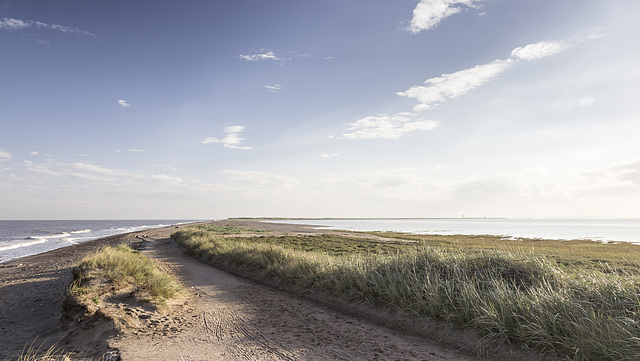
Spurn north end view SW over the Spurn Neck


A visit to Spurn Point 26
Looking south-west from the landward end of Spurn, over the narrow Spurn Neck (the high spring tide wash-over zone). Spurn Point itself, and the two lighthouses, are visible on the skyline towards the right.
Looking south-west from the landward end of Spurn, over the narrow Spurn Neck (the high spring tide wash-over zone). Spurn Point itself, and the two lighthouses, are visible on the skyline towards the right.
Amelia, Andy Rodker, Annemarie, Marco F. Delminho have particularly liked this photo
- Keyboard shortcuts:
Jump to top
RSS feed- Latest comments - Subscribe to the comment feeds of this photo
- ipernity © 2007-2025
- Help & Contact
|
Club news
|
About ipernity
|
History |
ipernity Club & Prices |
Guide of good conduct
Donate | Group guidelines | Privacy policy | Terms of use | Statutes | In memoria -
Facebook
Twitter

Fine capture!
Earthwatcher club has replied to Andy Rodker clubEarthwatcher club has replied to Amelia clubSign-in to write a comment.