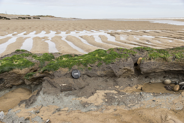
Spurn Neck close-up of peaty layer
Spurn Neck sand ripples 1
Spurn Neck sand ripples 2
Spurn Neck; looking out to sea
Spurn Neck view south
Spurn groyne 1
Spurn groyne 2
Spurn groyne 3
Spurn groyne and large vessel
Spurn Chalk Bank view north 1
Spurn Chalk Bank view north 2
Spurn Chalk Bank view WNW to Immingham
Spurn Warren view NE
Spurn Warren view SW to lighthouses
Spurn Warren view W to Grimsby
Spurn Warren view NE
Spurn High Lighthouse 1
Spurn High Lighthouse 2
Spurn High Lighthouse 3
Spurn Lower Lighthouse
Spurn lighthouses view NE
Spurn Warren view E to wind farm
Spurn east beach bank, swales and ripples 1
Rough Standhills early autumn pine avenue
Early autumn colours in Rough Standhills 4
Early autumn colours in Rough Standhills 3
Early autumn colours in Rough Standhills 2
Early autumn colours in Rough Standhills 1
Handfasting Ground devastation 2
Handfasting Ground devastation 1
Beech in the spotlight
Looking to Fulwood Hall
Wigley Farm fields view to Castle Dyke Lodge 3
Wigley Farm fields view to Castle Dyke Lodge 2
Wigley Farm fields view to Castle Dyke Lodge 1
Lonely sycamore and Wigley Farm fields
Lonely sycamore in September
Midnight clouds and stars
Comet Neowise from near Burbage Bridge
Altocumulus with fallstreaks
Cat's ear at ground level
Garden wilderness
Garden meadow
Spring meadow
Lichen on wall - detail
1/200 • f/5.6 • 24.0 mm • ISO 200 •
Canon EOS 600D
EF-S15-85mm f/3.5-5.6 IS USM
Location
Lat, Lng:
You can copy the above to your favourite mapping app.
Address: unknown
You can copy the above to your favourite mapping app.
Address: unknown
See also...
Keywords
Authorizations, license
-
Visible by: Everyone -
All rights reserved
- Photo replaced on 01 Oct 2020
-
211 visits
Spurn Neck Basement Till and peaty layer


A visit to Spurn Point 1
Low tide at Spurn Neck exposes the pale grey 'Basement Till', a lodgement till ('boulder clay') deposited by ice in the Wolstonian glaciation, 250,000 - 150,000 years ago. This is overlain by the chocolate-brown, rather peaty clay and silt, visible in the centre of the photo. This deposit, with its embeded woody plant remains represents the Ipswichian warm interglacial stage which lasted until 110,000 years ago. This in turn is overlain by the Skipsea Till, which comprises the low cliffs seen in the far distance, deposited by the last glaciation event, which finally ended in this area about 11,500 years ago.
The lens cap is 72 mm in diameter.
Frans Schols, neira-Dan have particularly liked this photo
- Keyboard shortcuts:
Jump to top
RSS feed- Latest comments - Subscribe to the comment feeds of this photo
- ipernity © 2007-2025
- Help & Contact
|
Club news
|
About ipernity
|
History |
ipernity Club & Prices |
Guide of good conduct
Donate | Group guidelines | Privacy policy | Terms of use | Statutes | In memoria -
Facebook
Twitter

Sign-in to write a comment.