X
Lyon (69) 9 juillet 2014. Vue sur Fourvière depuis…
HFF ...
sunrise may 25 mai 2017 lever de soleil
ciel gris / dark sky
un pont pour les nuages / a bridge to the clouds
avant la pluie / before the rain
before the rain / avant la pluie
ciel nuages 20170529
Rocky mounts of Sicily.
Shelter harbour and beach.
Gulf of Castellammare.
Ruins of medieval castle.
Salt pits, with Trapani on the background.
ciel d'orage / stormy sky
happy fence friday
safe harbour
gravelled is my road
ITALIE
houses in the desert
Depuis la passerelle himalayenne à Rochemaure (Ard…
Mestia
august 22, 2017
a view to Regla
lampposts in the sky
Wremen harbour
Loulé's Market (1908).
Barbican of Loulé's Castle.
Tracery on chimney.
le ciel du Forez
PORNIC - BLUE PLANET/PLANETE BLEUE
ANGERS
ANGERS
après l'orage, l'arc-en-ciel - Drôme
après l'orage - Drôme
Fitz Roy - stormy
SARDAIGNE
MONTFORT le GESNOIS
MONTFORT le GESNOIS
le solitaire
paix!
aube nouvelle
LA LOIRE
meadows for you and me
View from the airport terminal.
Location
Lat, Lng:
You can copy the above to your favourite mapping app.
Address: unknown
You can copy the above to your favourite mapping app.
Address: unknown
See also...
Keywords
Authorizations, license
-
Visible by: Everyone -
All rights reserved
-
500 visits
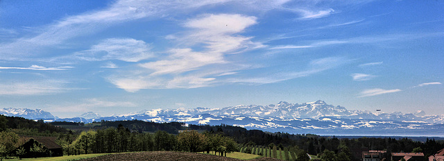
Panoramablick bei Föhnwind von Gornhofen über den Bodensee in die Schweiz bis zum Säntis (Note)


best on Black - fond noir svp - am besten auf schwarz - Z -
2 Notizen
Sichtwete (Luftlinie) ca. 60 km
Aufnahme von unserer auf den 30. April vorverlegte 1. Maiwanderung
zusammengesetzt aus 2 Bildern.
Translate into English
2 Notizen
Sichtwete (Luftlinie) ca. 60 km
Aufnahme von unserer auf den 30. April vorverlegte 1. Maiwanderung
zusammengesetzt aus 2 Bildern.
Stephan Fey, Stevia, , and 18 other people have particularly liked this photo
- Keyboard shortcuts:
Jump to top
RSS feed- Latest comments - Subscribe to the comment feeds of this photo
- ipernity © 2007-2025
- Help & Contact
|
Club news
|
About ipernity
|
History |
ipernity Club & Prices |
Guide of good conduct
Donate | Group guidelines | Privacy policy | Terms of use | Statutes | In memoria -
Facebook
Twitter

Marie-claire Gallet has added❤
Erich
Der Säntis (Notiz im Bild) liegt etwa 63 km Luftlinie entfernt vom Aufnahmeort.
Sign-in to write a comment.