View of the gods
Granite scenery
On approach
Happy New Year and H. A. N. W. E. !
Parque de Oeste, Madrid
Palma panorama
Christmas Day 2018, Valderrey, Algete, Madrid
Ferry across the Med
View from house to the Sierra de Guadarrama
Cistus / jara / rock rose.
Magaluf
Sally's Bottom, Nancecuke.
Blue Med
Pyrenees
Convento de San Antonio, Sierra de La Cabrera.
Saltcoats in the snow
Saltcoats Lane
Bustarviejo Valley from The Sierra de La Cabrera
Early morning from the house - La Sierra de La Cab…
How green is my valley
Sierra de La Cabrera. H. A. N. W. E. everybody!
Last winter. HFF everyone!
TOULOUSE-FRANCE LE CANAL DU MIDI A PORT SUD
Country path, Fuente el Saz de Jarama.
Gooden Hearne. Between Sally's Bottom and Portreat…
Coastal mountains
TOULOUSE - FRANCE LE CANAL DU MIDI A PORT SUD
Bustarviejo Valley from La Sierra de La Cabrera
view from Kunderberg ,voerendaal to Heerlen
Sharjah
TOULOUSE - FRANCE, street photography. Modèle Mari…
Peña del Tejo
TOULOUSE - FRANCE, street photography. Modèle Gwen
Desert junction
RIBADEO- Espagne LA PLAGE DES CATHEDRALES
SEGOVIE - ESPAGNE LA CATHEDRALE
Meeting of the waters
Rocky Points
Newdowns Head and Man-and-His-Man (or Cow-and-Calf…
Gray Day at Hamilton Cove
Las Agujas de Cancho Gordo
Location
Lat, Lng:
You can copy the above to your favourite mapping app.
Address: unknown
You can copy the above to your favourite mapping app.
Address: unknown
See also...
Keywords
Authorizations, license
-
Visible by: Everyone -
All rights reserved
-
528 visits
Mountain range


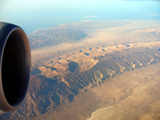
Along the southern coast of Iran, heading west on a flight from Dubai to Manchester. The island of Kish is just visible above the engine, with Hendorabi top centre and top right is Lavan. Looks like a series of impact craters on the mountains below.
Marco F. Delminho, Fred Fouarge, Earthwatcher, Eunice Perkins and 3 other people have particularly liked this photo
- Keyboard shortcuts:
Jump to top
RSS feed- Latest comments - Subscribe to the comment feeds of this photo
- ipernity © 2007-2024
- Help & Contact
|
Club news
|
About ipernity
|
History |
ipernity Club & Prices |
Guide of good conduct
Donate | Group guidelines | Privacy policy | Terms of use | Statutes | In memoria -
Facebook
Twitter

Tractacus club has replied to slgwv clubslgwv club has replied to Tractacus clubIn this case the mountains are part of a dissected anticline - an long arch-type fold a bit like a long, upturned boat which you can fairly readily visualise by following the lines of the bedded rocks (where they meet the flat desert) along the length of the fold; the beds turn around the 'nose' in the distance and then back along the far side. You can see similar structures in your other aerial shot of this region.
Although salt tectonics do occur in Iran and other locations in the Middle East, I'm almost certain that these are true tectonic folds formed by crustal earth movements. If you look at this area on Google Earth, you can see a whole range of en-echelon, interlocking, anticlines and synclines, which strongly suggests tectonic fold mountains.
Sign-in to write a comment.