Zabriskie Point
Gray's Crossing
Sierra Juniper
Heenan Lake
Joshua Tree National Park
Half Moon Lake
Frank
Golden Gate and HFF
Trees of Mystery
Sunday pleasure @ Venice Beach
Wolf Creek Lake
Terrace Vista
Webber Falls
San Francisco and Alcatraz
Hochhaus am Union Square San Francisco 08.17
In den Srassen von San Francisco 09.17
HFF in Santa Monica
White Rock Lake
Tamarack Lake, Ralston Lake
09.11.2001 not forgotten
Rainmaker Fountain in Palmsprings (1 PiP)
Scotty's Castle, Feb. 1980 HFF
Scotty's Castle, Main Gate (HFF)
Algodones Dunes / pandemic Thanksgiving 2020 (# 05…
Looking toward California
Silver Mountain Jail
Sierra Juniper
streets of San Francisco - 1986
Dumbarton Bridge, California
Battery Mendel
Noble Lake
Noble Lake
Truckee River
Crag Lake
Beaver's work--
Lake Genevieve
HBM @ Solvang, California
Gnarly
Morro Bay sunset ( #0527)
Kinney Reservoir
Yaar!!
Wolf Creek Falls
Lower Highland Lake
Twinned Sierra Juniper
Wolf Creek Meadows
Location
Lat, Lng:
You can copy the above to your favourite mapping app.
Address: unknown
You can copy the above to your favourite mapping app.
Address: unknown
See also...
Keywords
Authorizations, license
-
Visible by: Everyone -
All rights reserved
-
164 visits
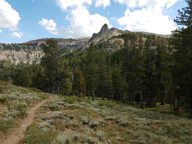
PCT and Spire off Arnot Peak


Carson-Iceberg Wilderness, Sierra Nevada, California, looking south. The Pacific Crest Trail (PCT) is on the left; the obvious saddle below is Wolf Creek Pass (not to be confused with the one in Colorado!) The prominent skylined spire evidently doesn't have a name but is at the end of a north-trending ridge off Arnot Peak (10,054 ft/3064 m). Judging by the topo map, the spire is around 9700 ft/2957 m. Elevation of the PCT here is about 8700 ft/2652 m.
LutzP, Pam J, Marie-claire Gallet and 2 other people have particularly liked this photo
- Keyboard shortcuts:
Jump to top
RSS feed- Latest comments - Subscribe to the comment feeds of this photo
- ipernity © 2007-2025
- Help & Contact
|
Club news
|
About ipernity
|
History |
ipernity Club & Prices |
Guide of good conduct
Donate | Group guidelines | Privacy policy | Terms of use | Statutes | In memoria -
Facebook
Twitter

Admired in:
www.ipernity.com/group/tolerance
Sign-in to write a comment.