20200927 161426 001
20200927 161558 001
20200927 161606
20200927 162403 001
20200927 163202 001
20200927 170240 001
20200927 170907 001
20200927 171107 001
20200927 172927
20200927 173236
20200927 173420
Ah, the sound of cowbells in the wilderness!
IMG 0926 adj
IMG 0929 adj
IMG 0930 adj
IMG 0931 adj
IMG 8775
IMG 8777
IMG 0935 adj2
Sierra Nevada Crest
IMG 0939 adj2
IMG 0940
IMG 0942
20200927 161132
20200927 161129
20200927 160336 001
Noble Lake
20200927 152206 001
IMG 0920
IMG 0917
IMG 0916
20200927 145817 001
20200927 145340 001
20200927 145155 001
Noble Lake
20200927 143805 001
20200927 143306 001
20200927 142853 001
20200927 142017
20200927 142012
20200927 140946 001
20200927 140859 001
20200927 140657
20200927 140644 001
Prayer flags close-up
Location
Lat, Lng:
You can copy the above to your favourite mapping app.
Address: unknown
You can copy the above to your favourite mapping app.
Address: unknown
See also...
Keywords
Authorizations, license
-
Visible by: Everyone -
All rights reserved
-
151 visits
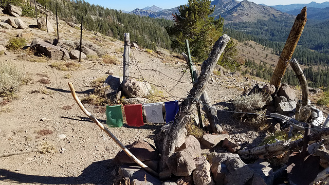
Tibet in the Sierra?


On the Pacific Crest Trail at an unnamed pass in the Sierra Nevada, California, about 7 trail miles south of Ebbetts Pass. Looking south. From a distance we thought someone was drying laundry, but these appear to be prayer flags, covered with writing in what I assume is Sanskrit (inset). Go figure--
We're in the Carson-Iceberg Wilderness here, named for the Carson River and a rock formation called The Iceberg. The barbed-wire fences are still in use because cattle grazing was grandfathered in when the wilderness was established!
This pass doesn't look like much, but since it's on the Sierra crest it marks a major drainage divide. To the south and west streams flow generally westward, finally joining the San Joaquin and flowing out to the Pacific at San Francisco Bay. Streams flowing easterly, OTOH, eventually join the landlocked Carson River in the Great Basin, which ends at the Humboldt Sink about 120 miles east of here in Nevada.
William Sutherland, Marie-claire Gallet, Pam J have particularly liked this photo
- Keyboard shortcuts:
Jump to top
RSS feed- Latest comments - Subscribe to the comment feeds of this photo
- ipernity © 2007-2025
- Help & Contact
|
Club news
|
About ipernity
|
History |
ipernity Club & Prices |
Guide of good conduct
Donate | Group guidelines | Privacy policy | Terms of use | Statutes | In memoria -
Facebook
Twitter

ALSO YOUR USUAL WONDERFUL GEOLOGICAL COMM ENTRY.A
AND PRAYER FLAGS. ITS A HIGH POINT.. THE WIND TAKES TH PRAYERS UPWARD AND ONWARD.
slgwv club has replied to Pam J clubAdmired in:
www.ipernity.com/group/tolerance
Sign-in to write a comment.