Coyote on a mission
Firing Port in the Fort Edgecomb Palisade
Heavy Timbers
Social distancing
Stronghold Canyon
Historic Photo -- Hitchcock Gets Inspiration
Acadia Nightfall
A Couple of Friends
Lupins, Denali National Park, Alaska (H.A.N.W.E.)
The Ghost Trees of Shenandoah
Lighthouse? Can't Get There From Here
Up From the West Quoddy Shore
Down the Lighthouse Steps
Old Gull, Young Gurl (3 of 3)
Old Gull (1 of 3)
Kinney Reservoir
Erosion!
Lake Genevieve
Crag Lake
Gray Lake
Noble Lake
Tahoe Meadows and Washoe Lake
Shamrock Lake
West Gemini Bridge
Golden Gate Bridge
Eagle guardian?
Snowy path
Purple Wildflower
Snake River Canyon
Mt. Elwell (7818 ft/2383 m) and Lakes Basin
Great Sand Dunes National Park, Colorado
Grand Canyon Sunset
A Ciénega
The Mustang Mountains
The Struggle Is Real
Stone birds of prey?
Burn
Wallowa Lake
Canyon of the Grande Ronde
Wallowa Mountains
Morning calm
Mt. Etna
Duck Soup Pond
Arch Rock
Patriarchs
Location
Lat, Lng:
Lat, Lng:
You can copy the above to your favourite mapping app.
Address: unknown
Lat, Lng:
You can copy the above to your favourite mapping app.
Address: unknown
See also...
Keywords
Authorizations, license
-
Visible by: Everyone -
All rights reserved
-
584 visits
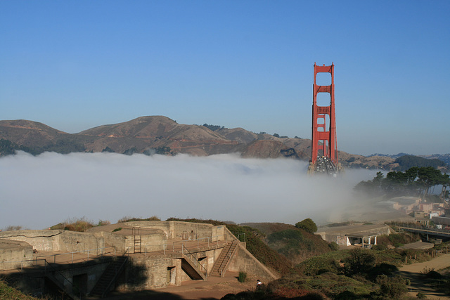
Coastal fortifications at The Presidio


San Francisco, looking north across (yes!) the Golden Gate to the Marin Headlands. "Presidio" means "fort" in Spanish--the original name was El Presidio Real de San Francisco, The Royal Fort of Saint Francis--and the fortification was established by the Spanish in 1776 to try to consolidate their claims on this part of New Spain. The Presidio was inherited by Mexico after Mexican independence, and then by the U.S. after the treaty of Guadalupe Hidalgo in 1848. It remained an important center for US coastal fortifications for something like a century, but by the mid-20th century advances in military technology had rendered it obsolete. (Who needs coastal artillery when radar or a satellite can identify a threat hundreds of miles offshore, and aircraft or a cruise missile can then take it out?) The grounds were finally taken over by the National Park Service in 1994. Many of the old military installations are now being managed as historical sites, some of the buildings have been refurbished and repurposed as high-end office space, and some of the coastal areas by the Bay have been restored as wetlands.
The concrete foundations in the foreground are from U.S. coastal batteries dating from ca. the 1890s (upper left inset). A close-up of one of the cannon foundations is shown in the inset below. None of the actual cannons or their metal mounts are left, presumably having been salvaged as scrap over the years.
The prominent highway cutting across the Marin Headlands opposite is Conzelman Rd, coming out of the Golden Gate National Recreation Area. I came back that way from the Point Bonita lighthouse, and took some pictures looking back this way (inset on the highway, approximately at the photo point).
LutzP, Reyk, Marco F. Delminho, Frans Schols and 15 other people have particularly liked this photo
- Keyboard shortcuts:
Jump to top
RSS feed- Latest comments - Subscribe to the comment feeds of this photo
- ipernity © 2007-2024
- Help & Contact
|
Club news
|
About ipernity
|
History |
ipernity Club & Prices |
Guide of good conduct
Donate | Group guidelines | Privacy policy | Terms of use | Statutes | In memoria -
Facebook
Twitter

Sign-in to write a comment.