Inspection committee
Dillon Reservoir
Assembly Hall Peak
Notch Peak
Trail Ridge Road
Looking toward Arches National Park
Sego, Utah
Eagle guardian?
The High Plateaus
Vega Reservoir
Sego Canyon Rock Art
Unnamed
Dropping into Red Canyon!
Navajo Bridge
Tusher Tunnel
Disappointment Valley
Dolores River
Needle Rock
Wedge Overlook
Buckhorn Wash
Slag
Shiprock, New Mexico
Trail to Cascade Falls
Parowan Gap
Petroglyphs
Fermé
Ben Teller: "They Shot Us Down Like Dogs"
Canyon de Chelly, AZ
Four Corners - Bob Lansing, Navajo Artist
Notch Peak
Unnamed
Green River
Missed!
Engineer Mountain
McPhee Reservoir
Better than a No Trespassing sign--
The Painted Wall
Doc Holliday's grave
Iron King Trail
Location
Lat, Lng:
Lat, Lng:
You can copy the above to your favourite mapping app.
Address: unknown
Lat, Lng:
You can copy the above to your favourite mapping app.
Address: unknown
See also...
See more...Keywords
Authorizations, license
-
Visible by: Everyone -
All rights reserved
-
759 visits
Burr Trail


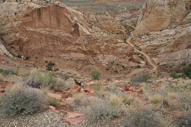
A road following a steep canyon thru the Waterpocket Fold, a monocline that forms the prominent landforms in Capitol Reef National Park, Utah. A monocline is a structure in which one side has been downdropped with respect to the other, with the overlying strata folded downward accordingly. Usually monoclines reflect high-angle faults in the subsurface. The prominent light-colored sandstone making the big cliffs and rounded domes is the Navajo Sandstone of Triassic-Jurassic age, a widespread stratigraphic unit in this part of the Colorado Plateau. Looking east.
The Burr Trail comes up this canyon in a set of steep switchbacks. It is named for John Atlantic Burr, who built the original trail in the 1880s for cattle(!) drives. The modern trail is graded and in good weather is (more or less) passable to ordinary passenger cars, but it gets washed out enough--particularly in monsoon season, as now!--that high clearance and 4wd are advisable. I crossed a flooded section of road getting to this point. The inset shows another view of the switchbacks.
The Burr Trail comes up this canyon in a set of steep switchbacks. It is named for John Atlantic Burr, who built the original trail in the 1880s for cattle(!) drives. The modern trail is graded and in good weather is (more or less) passable to ordinary passenger cars, but it gets washed out enough--particularly in monsoon season, as now!--that high clearance and 4wd are advisable. I crossed a flooded section of road getting to this point. The inset shows another view of the switchbacks.
Petar Bojić, , , Nouchetdu38 and 11 other people have particularly liked this photo
- Keyboard shortcuts:
Jump to top
RSS feed- Latest comments - Subscribe to the comment feeds of this photo
- ipernity © 2007-2024
- Help & Contact
|
Club news
|
About ipernity
|
History |
ipernity Club & Prices |
Guide of good conduct
Donate | Group guidelines | Privacy policy | Terms of use | Statutes | In memoria -
Facebook
Twitter

Admired in:
www.ipernity.com/group/tolerance
Have a nice weekend.
slgwv club has replied to Janet Brien clubslgwv club has replied to Don Barrett (aka DBs… clubwww.ipernity.com/doc/289859/47812830/in/album/1211978
I crossed this one the way in. I came in from the east, on the Notom road.
Don Barrett (aka DBs… club has replied to slgwv clubSign-in to write a comment.