IMG_8488_adj
IMG_8489_adj
IMG_8490_adj
IMG_8491_adj
IMG_8492_adj
IMG_8493_adj
IMG_8494_adj
IMG_8495_adj
IMG_8496_adj
IMG_8497_adj
IMG_8498_dj
IMG_8499_adj
IMG_8500_adj
IMG_8501_adj
IMG_8502_adj
IMG_8503_adj
IMG_8504_adj
IMG_8505_adj
IMG_8506_adj
IMG_8508_adj
IMG_8509_adj
IMG_8510_adj
IMG_8511_adj
IMG_8486_adj
IMG_8485_adj
IMG_8484_adj
IMG_8483_adj
IMG_8482_adj
IMG_8480_adj
IMG_8479_adj
IMG_8478
IMG_8477
IMG_8476_adj
IMG_8475_adj
IMG_8474_adj
IMG_8473_adj
IMG_8472_adj
IMG_8471_adj
IMG_8470_adj
Looking back...
You've been warned...
IMG_8461
IMG_8460
IMG_8459
IMG_8458
Location
Lat, Lng:
You can copy the above to your favourite mapping app.
Address: unknown
You can copy the above to your favourite mapping app.
Address: unknown
See also...
See more...Keywords
Authorizations, license
-
Visible by: Everyone -
All rights reserved
-
503 visits
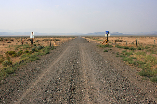
State Line


Washoe County Rd 34 entering Oregon from Nevada, where the route becomes Lake Co. 3-15 (Coleman Valley Rd.) Pretty arbitrary, and in a very remote part of both states!
And that's where the history comes in. The state line here is the 42nd parallel, as well as could be established by 19th century technology. This parallel now defines the northern boundary of California, Nevada, and western Utah and the southern boundary of Oregon and Idaho, and _that's_ because the 42nd parallel was the northern limit, by treaty, of the Spanish land claims, which were later inherited by Mexico, and then by the U.S. after the treaty of Guadalupe Hidalgo in 1848. (All this, it goes without saying, without any consideration of, or input from, the local Native American tribes.)
So, once both sides of this line were under US sovereignty, wouldn't it have made more sense to make the new state lines less arbitrary? John Wesley Powell, one of the "founding fathers" of the US Geological Survey, thought so, and advocated drawing state lines along watershed boundaries. He is quoted as saying something like, "You can make work for surveyors, or for lawyers." Well, this is America! Of course Congress made work for lawyers-- ;)
Nautilus, William Sutherland have particularly liked this photo
- Keyboard shortcuts:
Jump to top
RSS feed- Latest comments - Subscribe to the comment feeds of this photo
- ipernity © 2007-2025
- Help & Contact
|
Club news
|
About ipernity
|
History |
ipernity Club & Prices |
Guide of good conduct
Donate | Group guidelines | Privacy policy | Terms of use | Statutes | In memoria -
Facebook
Twitter

Admired in:
www.ipernity.com/group/tolerance
Sign-in to write a comment.